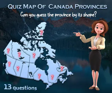
Canada map of provinces and territories quiz. GeoQuizGames offers you a great 2D localization quiz game with background music to let you relax while studying. No problem if you are not up to the task, you can restart the game at any time to consolidate your knowledge of the location of Canadian provinces on nice maps. Your turn to play!
Are you an expert in the geography of Canada? Test your knowledge with this canada map of provinces and territories quiz game and find out if you are a geography genius.
Let's find out how well you know Canada map of provinces and territories. Click on the province from the choices presented to answer correctly. You have a 30% chance of guessing the location of a country correctly, however, if you use a tip, you will have a 60% chance.
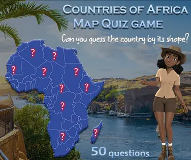
Geography is the best way to take a break and have fun! This quiz will show you all the countries of the world. Learn to recognize them by their shape or their flag. In this case if you met one or more of our 20 quizzes, you are now able to solve this relatively simple test on map of Canada. (13 questions). All in all, we have found several different approaches that can be used throughout an entire product description
This geography quiz is good for checking what you have learned about the location of canadian provinces and territories. To play, participants must match a single province/territory to its position on an outlined map of Canada.
Still think you know where the Canadian Provinces are? Only one way to find out!. You can also play Similar games on Free Study Maps
Play this Canada map of provinces and territories quiz. Which one do you live in?
Are you a geography genius? Prove it with this Canada map of Provinces and Territories quiz. Test yourself on the locations of all thirteen provinces as well as three territories - and don't forget, Nunavut is a territory, not a province! Learn the names of cities such as Quebec city, Toronto and Vancouver. This Canadian quiz game features slick 3D maps for each location to help you learn the land mass and get to know the various major cities. Give it your best shot!
Canadians pride themselves in their knowledge of Canadian provinces and territories. The land of the French, English and Native Americans, the Dominion of Canada is a unique country with its own characters, landscapes and values. This free quiz game will allow you to discover the beautiful maps of Canada as a country and take your first steps in geography thinking. You can play similar games on Playgeography
GeoQuizGames presents a fun map quiz game for kids and adults about Canada. In this geography quiz game you have to find out the provinces and territories of Canada on nice maps in 3D. The game offers background music to let you relax while studying and several distance levels, time limits, etc. You don't know everything about the location of Canadian provinces and territories? Do not worry, you can resume your geography information anytime to consolidate your knowledge.
Related games
You might also like


Canada provinces and territories map quiz will help kids learn more about Canada
Canada is a vast country that spans an area larger than Western Europe. It has four distinct regions: Atlantic Canada, Quebec, Ontario, and British Columbia. Each region has its own unique culture, history, and landscape.
The Canadian provinces and territories are divided into two groups: Maritime Provinces (Atlantic Canada) and Prairie Provinces (British Columbia, Alberta, Saskatchewan, Manitoba). There are also three territories: Yukon, Northwest Territories, and Nunavut.
Which province has the highest population density?
Newfoundland and Labrador has the highest population density at 1,842 people per square kilometer. Quebec has the lowest with 856 people per square kilometer, followed by Ontario with 936 people per square kilometer and British Columbia with 1,065 people per square kilometer
Ontario
The Canadian provinces and territories are divided into three groups based on size and climate. Atlantic Canada includes the provinces of New Brunswick, Nova Scotia, and Prince Edward Island. These provinces share similar climates and landscapes. They also have a strong cultural identity. In contrast, Western Canada consists of the provinces of Alberta, British Columbia, Manitoba, Saskatchewan, and Yukon. This group shares a common culture and landscape. Finally, Northern Canada includes the remaining provinces and territories. It is home to the largest land mass in North America.
Quebec
The province of Quebec has two official languages: French and English. However, there is no official language policy in place. As such, people who speak both languages are considered bilingual.
Alberta
The Canadian provinces and territories are divided into three regions: Atlantic, Central, and Pacific. Each region contains several provinces and territories.